The Torensduin in Egmond aan Zee: 101 steps to a vanished lighthouse
The Torensduin is a viewpoint in the middle of Egmond aan Zee, on the spot where the Zuidertoren lighthouse stood until 1915. A stairway of 101 steps runs up, to about 28 metres above NAP, the Dutch ordnance datum. No guide names that height, we looked it up ourselves in the elevation dataset of Rijkswaterstaat.
Beheerder
overig
Hoogte
28 m
Beside the Museum van Egmond a stairway of 101 steps climbs a dune, right in the middle of the village. At the top you stand at about 28 metres above NAP (Normaal Amsterdams Peil, the Dutch ordnance datum, roughly mean sea level), on the spot where the Zuidertoren stood until 1915. Of that tower nothing is left, of the view there is plenty.
Where exactly is the Torensduin?
At 52.61690 / 4.62616, in the middle of Egmond aan Zee, a coastal village in the province of Noord-Holland. That is the coordinate of the viewpoint in OpenStreetMap, node 1367206998. Watch the name, because there is also a street in the same village called Torensduin, a few hundred metres further east. Set your navigation on the dune and not on the street.
The Museum van Egmond at Zuiderstraat 7 lies 92 metres away, calculated from the coordinates. From the point this guide uses for the village centre it is 161 metres. Egmond Online describes the route as: beside the museum onto the pavement, and then the stairs. So you do not have to go inside. The museum itself is open in 2026 from 25 April to 1 November inclusive, daily from 14.00 to 17.00.
How many steps go up?
- That is recorded as
step_counton the stairway in OpenStreetMap, way 122315777, and the top end of that stairway lies 4.7 metres from the viewpoint. The stairway is about 81 metres long and paved.
Steep it is not. At the bottom the Rijkswaterstaat elevation dataset reads 14.3 metres and at the top 27.7, so you climb about 13.4 metres, spread over 101 steps. That comes down to steps of around 13 centimetres, lower than an ordinary household staircase. Egmond Online calls it a lazy dune stairway, and not for nothing.
That same map adds three things you want to know beforehand: no handrail, no ramp beside it and no lighting. In the dark you stand here without a torch.
How high is the Torensduin?
About 28 metres above NAP. No guide, no municipality and no manager publishes a height for this dune, so we looked it up ourselves in the Actueel Hoogtebestand Nederland, the national elevation model of Rijkswaterstaat, the Dutch national water authority, in the ground level map with a half metre grid (layer dtm_05m, retrieved through PDOK, the national geodata portal, on 6 September 2026).
At the viewpoint itself that map reads 27.8 metres. The highest point within 30 metres around it is 28.2 metres. That is why this page says 28 and not 27.83: it is a measurement we took and not a figure anyone has published, and then a decimal is pretending to know it more precisely than you do. With that coordinate and that layer you can check it yourself.
As a check we applied that method at two places where a figure is known. At De Bleek Viewpoint, where OpenStreetMap names 33 metres, the elevation dataset gives 33.9. At the Catrijper Nok, officially 55.4 metres after the measurement of 2014, the highest value in the surroundings comes out at 55.2. Each time the difference is less than a metre.
Put it beside the neighbours and you know what 28 metres is worth here: the Klimduin in Schoorl is 51 metres, the Catrijper Nok 55.4, De Bleek Viewpoint 33 and the Piramideduin near Petten 26.
What do you see from the top?
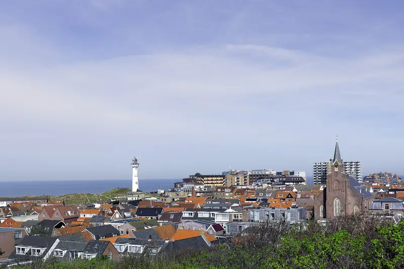
Sea, village and dunes, and the Van Speijk lighthouse. This is one of the few places where you can still clearly see that Egmond was built in the dunes instead of beside them.
According to search results the local organisation Parel aan Zee has put up information boards there about the maritime history of the village. The page that was supposed to carry that would not load for us, so how many boards there are and what is on them we have not been able to check at the source.
Which tower stood here?
The Zuidertoren, the smaller of the two lighthouses Egmond aan Zee had. The first stone went into the ground on 8 May 1833 and on 30 September 1834 the lights were lit for the first time, according to the foundation behind the Van Speijk lighthouse. Together with the Noordertoren, today’s J.C.J. van Speijk, it formed a line of lights at night that ships steered by.
That the Zuidertoren was lower than the Noordertoren came from its standing on this higher dune. The Noordertoren is 28 metres high according to Wikipedia, about as much as this dune.
When the North Sea Canal opened in 1876 and IJmuiden got towers of its own, the Zuidertoren lost its function. Exactly when the light went out is something the sources do not agree on. The Van Speijk foundation names 1 July 1892, Wikipedia holds to 1891 and Egmond Online writes that the lights burned until the end of 1891. In search results 1905 also turns up, but that year we have found on no page ourselves.
About the end there is no doubt: in 1915 the tower was sold for demolition. Nothing of it has been preserved, not even the foundation.
Can you get there with a wheelchair or a pushchair?
No. OpenStreetMap sets wheelchair=no on this viewpoint, and the stairway up to it has no handrail and no ramp beside it. A second route to the top, a sloping path from another side for instance, is not on the map. Whether one is there in the field after all, we have not walked out on the spot.
Where can you park?
Paid, and you stand in the village whatever happens, because this dune has no car park of its own. Egmond aan Zee falls under the paid parking scheme of the municipality of Bergen. From March to October inclusive you pay daily from 10.00 to 19.00, from November to February inclusive on Saturday and Sunday only, in those same hours. On winter weekdays you park free.
The municipality names no amount on that page itself and refers you on to Parkeer Service Bergen. Elsewhere in this guide 2.45 euros per hour stands as the tariff for 2026. The daily maximum for the zone around Egmond aan Zee, and how many metres you walk to the stairs from which car park, we have not been able to establish.
Can the dog come?
We do not know, and that is because we also do not know who is in charge here. Egmond aan Zee lies in the municipality of Bergen and the dune lies inside the built-up area, so the municipality is the obvious candidate, but we have found nowhere in black and white who owns or manages it. That is why the manager field on this page says “overig”, other, and not “Gemeente Bergen”.
For the beach of Egmond aan Zee the ordinary beach rules of the municipality of Bergen do apply, and those change on 1 January 2027. Whether a rule of its own is posted on this dune is in no source we have checked. Read the sign at the stairs.
Part of: Everything about Egmond aan Zee · Lighthouse, promenade and plenty of places to eat