Walking near Egmond aan Zee: the Albertdalpad, 3.9 kilometres
The Albertdalpad is the longest waymarked route that starts in Egmond aan Zee itself: 3.9 kilometres through the Noordhollands Duinreservaat, with posts carrying a blue triangle. The area belongs to PWN, so you need a duinkaart, a dune access pass. A day pass costs 2 euros.
Two waymarked routes of PWN, the provincial water company of Noord-Holland, begin in Egmond aan Zee itself: the Albertdalpad of 3.9 kilometres and De Lankies of 2.8 kilometres. This page is about the Albertdalpad, the longer of the two. Both run through the Noordhollands Duinreservaat, and that has one consequence you do not have a good ten kilometres further north, in the Schoorlse Duinen (the Schoorl dunes).
Where does the Albertdalpad start?
There are two entrances. If you begin in the village, you walk into the dunes at the eastern end of the Churchilllaan, on the southern edge of Egmond aan Zee. That is where the paving stops and a sand track begins. In OpenStreetMap that point is at 52.61389 north and 4.62935 east.
The second entrance is called De Bleek and lies outside the village, between Egmond aan den Hoef and Egmond aan Zee. For that you turn from the Nieuwe Egmonderstraatweg onto the Van Oldenborghweg; after roughly a kilometre the entrance is on the right.
Whether the route is a loop you can pick up at either entrance, none of the sources we have read says. We have not walked it ourselves, so it is not stated here.
How long is the route really?
That depends on whom you ask, and that is not a flippant remark.
- Natuurwegwijzer, the route portal of the Noord-Holland site managers, which names PWN as its source: 3.9 kilometres.
- WandelWeb, which calculates the length from a GPS track: 3.6 kilometres.
- Noordhollandseduinen.nl, the regional tourist site: 3.5 kilometres.
We keep to 3.9 kilometres, because that is the figure that goes back to the manager itself. Four hundred metres of difference over four kilometres is not an arithmetic error either but a difference in measurement: the portal describes the waymarked route, WandelWeb a track that was walked.
The walking time is given nowhere. WandelWeb names 46 minutes, but that is their own 3.6 kilometres divided by a standard speed, not a measured time. We therefore put no duration in this guide.
Do you need a dune pass here?
Yes, and that is exactly the difference with the dunes most people think of. The Albertdalpad lies in the Noordhollands Duinreservaat, and that belongs to N.V. PWN Waterleidingbedrijf Noord-Holland, not to Staatsbosbeheer, the Dutch state forestry service. In the Schoorlse Duinen of Staatsbosbeheer you pay only for parking and walk into the dunes free. Here you buy a pass in advance.
PWN asks for a valid ticket from every visitor aged 18 or over. The prices on PWN’s own order page, checked on 6 September 2026:
- day pass, valid 1 day: 2 euros
- week pass, valid 7 days: 6 euros
- annual pass digital 14.50 euros, on plastic 18 euros
- three-year pass digital 42.50 euros, on plastic 47.50 euros
If you cannot show a valid duinkaart at a check, you risk a fine of 109 euros including administrative costs, according to PWN.
There are two PWN ticket machines in and around the village. The southern one lies in the dune edge at 52.61584, 4.62889. At the northern one, at 52.62364, 4.62475, OpenStreetMap carries the note that it often does not work. That is a note from a volunteer, not a statement from PWN, but simply buy your pass online before you set off.
Two rules you easily miss: you may visit the reserve only between sunrise and sunset, and you must stay on the official paths. Going off the path is forbidden here.
How hard is the walking?
PWN attaches no difficulty grade to its routes and the route portal does not do so either. The “average” on this page is therefore ours, not the manager’s.
It is in the surface, not in the length. The route goes through high dunes and the sand here lies loose. A visitor who left a review on Natuurwegwijzer calls it a perfect route for anyone who likes loose sand, and that is exactly the right warning. From the GPS track, WandelWeb calculates 24.4 per cent surfaced and 75.6 per cent unsurfaced; the surfaced part is the Van Oldenborghweg.
How much height gain you make, we have not been able to establish. No elevation profile is attached to the route and we have not measured it, so that figure is not in this guide.
Can the dog come along?
Yes, but on a short lead, all year round. In the access rules of the Noordhollands Duinreservaat, PWN writes that dogs are welcome on the surfaced and unsurfaced paths and that you always keep your dog on a short lead. If you go off the path, the dog may not come at all, because you are not allowed there yourself.
Off-lead areas are named elsewhere for PWN land, but they are not on the access rules page of this reserve. Whether there is an off-lead field somewhere in the Noordhollands Duinreservaat, we have not been able to establish. Assume a short lead.
That is stricter than what you are used to a few hundred metres away on the beach. On the beach at Egmond aan Zee, which falls under the municipality of Bergen, your dog may run free from 1 May to 1 October before 10.00 and after 19.00. In the dune reserve next door that does not apply, not even early in the morning.
Where do you park?
At both entrances, but we know what it costs at only one of them.
At the entrance in the village you pay. With ParkeerService of the municipality of Bergen, Egmond aan Zee falls in zone A: 2.45 euros per hour, rising after an hour and a half to 4.90 euros per hour. In zone A there is no daily maximum. That weighs more heavily than it seems on a walk of four kilometres, because you are almost certainly out for longer than an hour and a half, and that is exactly when the hourly rate doubles.
Paid parking applies from 1 March to 1 November daily from 10.00 to 19.00, and from 1 November to 1 March on Saturday and Sunday only. That applies on public holidays too. On winter weekdays you therefore park free. Rates for 2026, checked on 6 September 2026.
At the De Bleek entrance the route portal names no paid parking; that note appears only with the entrance in Egmond aan Zee. Whether you really park free there and how many spaces there are, we have not been able to check with the municipality. That is why it is not stated here as a fact.
What do you come across along the way?
Zeedorpenlandschap, the seaside-village landscape, and here that is not a brochure word but the reason it looks different from Schoorl. For centuries the people of Egmond lived wedged between dune and sea and took everything that would burn out of the dunes. What remained are bare, almost treeless dunes with rectangular little plots in them. When the extraction of drinking water let the groundwater drop, the inhabitants dug their plots out to just above that water and threw the sand onto the edge. Right beside the village you see a lot of it.
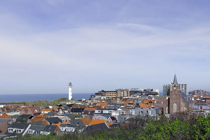
Halfway along, roughly at the highest point of the route, you look out over the Albertdal, where those same rectangular plots can be made out with the village in the background.
The pine plots you pass were planted in the 1930s, under the werkverschaffing, the Dutch unemployment relief work scheme. Unemployed men dug the ground over three spades deep and planted sixteen thousand young pines per hectare in it. Those woods are now a good eighty years old and set the picture.
In the inner dune grasslands, June turns red and yellow with greater yellow rattle and southern marsh orchid. Those grasslands have stayed rich in flowers because the people of Egmond grazed them with cows for centuries and because lime-rich seepage water comes to the surface. Where that water stands there are pools with common toads, natterjack toads and newts.
The name De Bleek comes from the eighteenth-century bleaching industry: linen woven from flax was laid out in the dunes to bleach, and a lot of dune water went into that. De Bleek is also an aardkundig monument, an earth-science site protected by the province, and the viewing dune De Kaap falls under it. How high De Kaap is, we have not been able to establish. In OpenStreetMap there is a De Bleek viewpoint at 33 metres, 1.2 kilometres south-east of the village (52.61035, 4.63688). Whether that is the same point, we have not established.
What you see along the way is described above on the basis of the route text that Natuurwegwijzer publishes in PWN’s name. We have not walked this route ourselves, and that is also stated in the provenance at the top of this page.
Part of: Everything about Egmond aan Zee · Lighthouse, promenade and plenty of places to eat